Что такое findslide.org?

FindSlide.org - это сайт презентаций, докладов, шаблонов в формате PowerPoint.


Для правообладателей

Обратная связь

Email: Нажмите что бы посмотреть 

Яндекс.Метрика

Презентация на тему The struve geodetic arcensemble of memorable sites

Study the following words
The Struve Geodetic Arc Ensemble of memorable sites Геодезическая дуга Струве Study the following words surveying -cooperation -  precise  -     meridian a plan of the earth’s surface   a flat shape with accuracy geodesy  memory  science  triangle   Make adjectives to measure  to collaborateto establishMake nouns from the following verbs measurementcollaborationestablishment The Struve Arc is a chain of survey triangulations stretching from Hammerfest These are points of a survey, carried out between 1816 and 1855 The original arc consisted of 258 main triangles with 265 main station Most of the station points don’t look like majestic constructions. They are 1. Norway (4)2. Sweden (4)3. Finland (6)4. Russia (2)5. Estonia (3)6. Latvia Since around 500 BC it had been known that the Earth was During those expeditions a new triangulation method was used. According to this The defeat of Napoleon, followed by the Congress of Vienna and the Struve, who was working at the University in modern Estonia (Tartu), decided It is an extraordinary example of scientific collaboration among scientists from different Nowadays, measurements are made using GPS instruments based on satellite positioning, some The Struve Geodetic arc in BelarusTriangulation point in Ivatsevichi. The Struve Geodetic arc in Belarus The Struve Geodetic arc. Silver commemorative coin, denomination: 20 rubles, BelarusThe Struve Geodetic arc in Belarus 1) The Earth is of regular spherical shape, isn’t it?2) What method 6) How many countries did the Arc pass when it was established
Слайды презентации

Слайд 2 Study the following words

Study the following words

Слайд 3 surveying -
cooperation -
precise -

surveying -cooperation - precise -   meridian -  slab


meridian -


slab -

Give one word which means the same

geodesy

collaboration

accurate

longitude

plaque, plate


Слайд 4 a plan of the earth’s surface

a plan of the earth’s surface  a flat shape with


a flat shape with 3 straight sides and 3

angles
a part of a circle or a curved line
a pile of stones which mark a special place
the branch of science concerned with determining the exact position of geographical points and the shape and size of the earth
a method of surveying in which an area is divided into triangles, one side (the base line) and all angles of which are measured and the lengths of the other lines calculated trigonometrically

Give one word which means the same

map

triangle

arc

cairn

geodesy

triangulation


Слайд 5 accuracy
geodesy
memory
science
triangle

accuracy geodesy memory science triangle  Make adjectives from the following


Make adjectives from the following nouns (mind

the stress)

accurate

geodetic

memorable

scientific

triangle, triangular


Слайд 6 to measure
to collaborate
to establish
Make nouns from

to measure to collaborateto establishMake nouns from the following verbs measurementcollaborationestablishment

the following verbs
measurement
collaboration

establishment


Слайд 7 The Struve Arc is a chain of survey

The Struve Arc is a chain of survey triangulations stretching from

triangulations stretching from Hammerfest in Norway to the Black

Sea, through 10 countries and over 2,820 km, which provided the first accurate measurement of a meridian. This helped to establish the exact size and shape of the planet and marked an important step in the development of earth sciences.

Слайд 8 These are points of a survey, carried out

These are points of a survey, carried out between 1816 and

between 1816 and 1855 by the German-born Russian astronomer

Wilhelm Struve. At that time, the chain passed through two countries: Union of Sweden- Norway and the Russian Empire. The Arc's first point is located in Tartu Observatory (modern Estonia) where Struve conducted much of his research.


Слайд 9 The original arc consisted of 258 main triangles

The original arc consisted of 258 main triangles with 265 main

with 265 main station points. Nowadays only 34 original

station points remain. In 2005, the chain was included on the World Heritage List as a memorable ensemble of these 34 sites.

Слайд 10 Most of the station points don’t look like

Most of the station points don’t look like majestic constructions. They

majestic constructions. They are marked by drilled holes in

rocks, iron crosses, cairns, or built obelisks.


Слайд 11 1. Norway (4)
2. Sweden (4)
3. Finland (6)
4. Russia

1. Norway (4)2. Sweden (4)3. Finland (6)4. Russia (2)5. Estonia (3)6.

(2)
5. Estonia (3)
6. Latvia (2)
7. Lithuania (3)
8. Belarus (5)
9.

Moldova (1)
10. Ukraine (4)
5 of 34 memorable sites are situated in Belarus

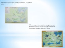
Nowadays the Arc of 34 memorable sites is stretching through 10 countries:


Слайд 12 Since around 500 BC it had been known

Since around 500 BC it had been known that the Earth

that the Earth was not flat. It had been

established in the 16th century that the Earth was round, but as early as the 17th century Isaac Newton suggested it might be slightly flattened at the poles. The expeditions sent to Lapland and Peru in the 18th century proved this theory correct. But the problem of the size of the Earth remained unsolved and had become even more complex, as it was known that it was not a perfect sphere.

History


Слайд 13 During those expeditions a new triangulation method was

During those expeditions a new triangulation method was used. According to

used. According to this method, a line could be

measured accurately, while the long distances were covered by a chain of triangles. These triangles with each of their sides (base lines) as long as 100 km and each triangle in the chain having one common base line with at least one other triangle and two common corners (station points) with another triangle.


Слайд 14 The defeat of Napoleon, followed by the Congress

The defeat of Napoleon, followed by the Congress of Vienna and

of Vienna and the decision in 1815 to establish

agreed international borders in Europe, required accurate mapping. These needs were strongly felt in Russia, where Tsar Alexander I provided Wilhelm Struve, German-born Russian astronomer with all the resources for his project for a new long geodetic arc

Слайд 15 Struve, who was working at the University in

Struve, who was working at the University in modern Estonia (Tartu),

modern Estonia (Tartu), decided that the arc would follow

a line of longitude (meridian) passing through the observatory of the university.

Слайд 16 It is an extraordinary example of scientific collaboration

It is an extraordinary example of scientific collaboration among scientists from

among scientists from different countries, and of collaboration between

monarchs for a scientific cause. In Finland, the Struve Geodetic Arc is also known as the Russo-Scandinavian meridian arc.
The meridian measurements carried out for the Struve Geodetic Arc are surprisingly accurate and the results have been used for many scientific purposes.

The Importance of the Arc


Слайд 17 Nowadays, measurements are made using GPS instruments based

Nowadays, measurements are made using GPS instruments based on satellite positioning,

on satellite positioning, some of them having an accuracy

of only a few millimeters. 
GPS – Global Positioning System

From triangulation to satellite-based measurement


Слайд 18 The Struve Geodetic arc in Belarus
Triangulation point in

The Struve Geodetic arc in BelarusTriangulation point in Ivatsevichi.

Ivatsevichi.


Слайд 19 The Struve Geodetic arc in Belarus

The Struve Geodetic arc in Belarus

Слайд 20 The Struve Geodetic arc. Silver commemorative coin, denomination:

The Struve Geodetic arc. Silver commemorative coin, denomination: 20 rubles, BelarusThe Struve Geodetic arc in Belarus

20 rubles, Belarus
The Struve Geodetic arc in Belarus


Слайд 21 1) The Earth is of regular spherical shape,

1) The Earth is of regular spherical shape, isn’t it?2) What

isn’t it?
2) What method was created in the 17th

century to establish the size of the planet?
3) Why did the European countries need accurate mapping in the 1st half of the 19th century?
4) Wilhelm Struve was a German astronomer who lived in Estonia, wasn’t he?
5) Why was the result of Struve’s work so important?

Answer the questions


  • Имя файла: the-struve-geodetic-arcensemble-of-memorable-sites.pptx
  • Количество просмотров: 121
  • Количество скачиваний: 0